Forums » Off-Topic
A Cool Photo
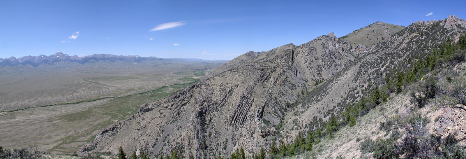
I'm almost done with my geology field camp class, and I've taken over 1,000 photos, and I can't resist sharing this panorama I took Friday:


Hm. Looks like the less-desert-y parts of Southern California.
Beaverhead Mountains in Idaho. The Lemhi Mountains are in the distance.
Very nice. The views at the end of a long hike up a mountain make it very worth it.
Speaking as a photographer, I like it... very nice work. If I might make one suggestion though, check out a "circular polarizing filter". It really brings out the blue in the sky, lends contrast to the clouds and in general just gives the picture more depth of color/contrast. Generally you can pick them up for... (depending on the brand), 25 to 300 dollars.
Thanks Ryan, I'll keep that in mind. I can't afford even a cheap one right now, but I'd like to get decent equipment at some point and really pursue photography as a serious hobby. Right now what I have is an Olympus C-4000 ZOOM. 4 megapixels and only 3x optical zoom, but it's a good, inexpensive, lightweight camera that serves me very well in the field at this point in my geology career (i.e., still a student). I've actually got a lot of photos that from an artistic standpoint are much better than this one, but I was really excited about this one strictly for the geology, haha. Yeah, I know, that makes me kind of a geology nerd, and that's okay.
And yes, moldy, the view from the top makes it very much worth it. I just camped for six weeks all over Idaho and Wyoming, and have honestly no idea how many peaks I hiked to in that time to make geologic maps. In six weeks I have probably eaten lunch on mountain tops at least a couple dozen times, and it is an amazing view every time. Including pieces of panoramas, I think I took nearly 1500 photos.
And yes, moldy, the view from the top makes it very much worth it. I just camped for six weeks all over Idaho and Wyoming, and have honestly no idea how many peaks I hiked to in that time to make geologic maps. In six weeks I have probably eaten lunch on mountain tops at least a couple dozen times, and it is an amazing view every time. Including pieces of panoramas, I think I took nearly 1500 photos.
Cool strata in the center of this pic. These mountains are an uplift? That's not a fault line running between the mountains, is it?
id not be suprised if it was leebs. looks like its also a river or sorts, you can see the extra vegetation there, usually a good sign of water.
I've almost finished my project, I'll share it if you'd like. This is an extremely interesting and complicated area geologically. This year was the first time anyone had hiked this ridge, and it did result in a previously unmapped thrust fault on our maps. The fault isn't in this photo, it is farther to the right (north-east) in a saddle in the mountains. This is typical of a thrust fault: The upper plate is highly deformed and the lower plate is relatively undisturbed. This is a photo of the upper plate, which was pushed eastward during the Sevier orogeny 140 million years ago, folding the strata very dramatically. This particular type of fold is what we call a "fault propagation fold", which means the rocks aren't broken but are about to be, and are likely broken much lower where we can't see and the break is being propagated as a fold. Farther north it becomes a true fault.
The trees you see in the foreground, no hands, are just the tiny bit of the north slope of the ridge I was standing on taking the photo, not part of the far ridge at all. It is typical for the northern slopes of these mountains to be highly vegetated and the southern slopes bare due to amount of sun. Plants need both sun and water, and they get plenty of sun but the snow takes longer to melt on the northern shadier slopes, resulting in a longer wet period than on the southern slopes, making a much better environment for the trees and shrubs. Also, it makes northern slopes a nightmare when it comes to geologic mapping, unless the tree line happens to follow a geologic contact. Changes in slope and vegetation are highly useful clues when there are no outcrops.
The trees you see in the foreground, no hands, are just the tiny bit of the north slope of the ridge I was standing on taking the photo, not part of the far ridge at all. It is typical for the northern slopes of these mountains to be highly vegetated and the southern slopes bare due to amount of sun. Plants need both sun and water, and they get plenty of sun but the snow takes longer to melt on the northern shadier slopes, resulting in a longer wet period than on the southern slopes, making a much better environment for the trees and shrubs. Also, it makes northern slopes a nightmare when it comes to geologic mapping, unless the tree line happens to follow a geologic contact. Changes in slope and vegetation are highly useful clues when there are no outcrops.
I'd be interested in seeing your project when it's done, I'm no scientist but geology is interesting.
Pretty.
Oh i found manbearpig!
Oh i found manbearpig!
Hahaha, yeah, that's my deviantART ID. I've been way too busy to keep it up to date, but in the next several weeks I hope to upload a couple hundred more photos... unless I'm too lazy. I took 1800 photos at field camp. Check out my gallery and favorites here: http://manbearpig82.deviantart.com/ . I'll post here again when I upload my more recent photos.